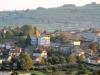
Randonnée 1200 Le Bois d'Ajoux - Rhône-Alpes, Rhône (69)
Rando proposée par: France Randos
Cette page a été affichée 3032 fois.
artez à la découverte du bocage, à la limite de la Bourgogne, découvrez la vue panoramique sur le Massif central depuis la roche d'Ajoux.

Type
Boucle

Distance
17.2 Km

Altitude maxi
900 M

Altitude mini
540 M

Durée
6h

Difficulté
difficile


Balisage
Non

Accès
Propières Rhône (69)

Départ
Le Haut de Ruère

Dénivelé
650 M

Référence carte
2929ET
| Photos | Type | Titre |
|---|---|---|
 |
Chambre d'hôtes | La Verrière |
 |
Gîte | La Musardière |
 |
Insolite (cabane...) | La Roulotte Beaujolaise |
 |
Gîte | Gîte de Toléron |
 |
Chambre d'hôtes | Combe Fleurette |
 |
Locations | Gîtes Grand'Roche et St Cyr |
| Photos | Nom | Présentation |
|---|---|---|
 |
Ferme de Saint-Laurent- Saint Laurent en Brionnais - 71800 |
Située en Bourgogne du Sud, la ferme équestre de St Laurent vous emènera en randonnée à cheval sur 2.3.4 ou 5 jours. Au départ du centre via la navette TGV ou au départ de la gare TGV de Macon-Loché ou du Creusot , votre voiture n'est pas indispensable pour venir profiter de votre... |
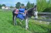 |
Relais Passiflore |
En famille ou entre amis, venez randonner avec un âne ! Pour une marche sportive avec nos Anes Randonneurs, ou une découverte de la campagne brionnaise au rythme d'une balade contée, le Relais Passiflore vous propose un séjour original. Au rythme de leur pas, actif... |

Météo
Impossible de charger les données météorologiques.
CLIQUEZ ICI pour enregistrer votre randonnée